
Pittsburgh Zoning Map - Zoning Max Height
By Carolyn Ristau

Introduction
Pittsburgh’s interactive zoning map includes many layers besides the zoning districts, most of which relate to requirements within or adjacent to the zoning code. For an overview on how to use the interactive zoning map, see our introductory post.
To select different layers, click the stack of paper in the upper right corner. The layers available are listed below. Today’s post features the Zoning Max Height layer, pictured above and in bold text below. Note: If you have been following our posts, this layer used to be known as the RIV Zoning Max Height. See below for more details.
Zoning
Zoning Districts
Zoning Districts Outlines
Zoning Max. Height Overlay
Height Reduction Zone Overlay
1500’ Major Transit Buffer
Parking Reduction Areas
North Side Commercial Parking Prohibited Area
Baum Centre Zoning Overlay
Inclusionary Housing Overlay District
RCO (Registered Community Organization) Areas
City Divisions
DPW Divisions
Neighborhoods
Council Districts 2012
Council Districts 2022 (Current)
Wards
Historic Preservation
Mexican War Street Historic Boundary
Individual City-Designated Properties
Pittsburgh City Historic Districts
Environment
RIV Riparian Buffer (125 Feet)
Stormwater Riparian Buffer
Floodplain Areas
Landslide Prone
Potential Steep Slopes Overlay Area
Undermined Areas
Addresses
Allegheny County
City Boundaries
Imagery 2021
The Zoning Max Height Layer
Overview
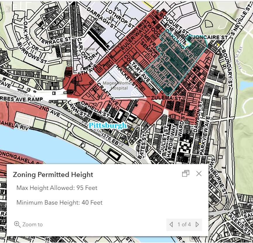
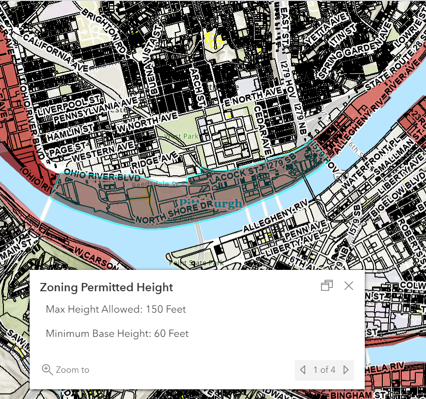
This layer of the interactive zoning map shows the maximum permitted heights for areas of the city in the zoning districts that have a multiple height subdistricts. To see the maximum permitted height:
Click on the site in question
Use the arrows to navigate between the pop-up windows as necessary
Relationship with Zoning
Most of Pittsburgh’s zoning districts include a maximum height requirement that is consistent throughout the district. The newest zoning districts are taking a different approach that creates subdistricts of height within the primary district or use-based subdistrict. It was first implemented in the RIV zoning districts and is being expanded to additional new districts as they are developed. As of August 2023, the zoning districts with height subdistricts are the RIV (Riverfront), UC-E (Urban Center Employment), UC-MU (Urban Center Mixed Use), and R-MU (Residential Mixed Use) zoning districts.
The starting point for the height requirements in the RIV zoning districts (RIV-RM, RIV-MU, RIV-NS, RIV-GI, and RIV-IMU) applies across all five districts with a minimum 24’ and maximum 60’ height thresholds for Primary Structures (905.04.E.3). From there, the height map layer indicates areas where the maximum height is reduced to 45’ and where the height may exceed 60’ provided the conditions enumerated in 905.04.E.3 are met.
For the UC-E (Urban Center Employment), UC-MU (Urban Center Mixed Use), and R-MU (Residential Mixed Use) zoning districts, each has its own minimum height requirement with different base maximum height requirements and bonus height maximums depending on which area a site is located. As with the RIV zoning districts, there are specific requirements that must be met to exceed the base height maximum. These may be found in 904.09.C.1 for the UC-E, 904.08.C.1 for the UC-MU, and 904.10.C.1 for the R-MU. The minimum, base maximum, and bonus maximum requirements for each of these districts are:
UC-E (Urban Center Employment) zoning district
Minimum Height: 40 ft.
Base Maximum Height: 85 ft.
Bonus Maximum Height: 120, 185, or 210 ft. depending on the subdistrict.
UC-MU (Urban Center Mixed Use) zoning district
Minimum Height: 24 ft.
Base Maximum Height: 40 or 65 ft.
Bonus Maximum Height: 65, 85, 95, 120, 140, or 185 ft. depending on the subdistrict.
R-MU (Residential Mixed Use) zoning district
Minimum Height: 24 ft.
Base Maximum Height: 40 or 85 ft.
Bonus Maximum Height: 85, 90, or 120 ft depending on the subdistrict.
Note: this pattern of separate map layers for uses and height harks back to the early zoning standards in Pittsburgh. The 1927 zoning map used separate layers to regulate permitted uses, maximum height thresholds, and area standards.
Challenges
In other districts, either the proposed project meets the maximum height requirement or it doesn’t; if it doesn’t, a variance may be requested from the Zoning Board. In the RIV, UC-E, UC-MU, and R-MU zoning districts, the maximum height a particular project is permitted to reach is based on the location, design, programming, and provision of community assets. Additional documentation, such as a shadow study, will likely be required as part of the application to demonstrate compliance with the requirements especially when seeking bonus height.
Conclusion
The Zoning Max Height layer is a key starting point for determining the maximum height permitted for a project in the RIV, UC-E, UC-MU, and R-MU zoning districts. Start with Pittsburgh’s interactive zoning map to check the maximum permitted height where the project is located. Then, refer to the height standards in the zoning code for the applicable zoning district to determine how the project can reach its ideal height within the maximum threshold.