
Residential Zoning by Race:
How Pittsburgh’s Zoning Districts Promote Different Housing Options for Black and White Residents
Part 6: The Race Factor
by Carolyn Ristau
Race as a Factor Influencing the Location of Zoning Districts
Race is the second factor that this research explores as influencing the location of zoning districts in Pittsburgh. This analysis explores the correlation between the racial demographics of the city by census tract and the three zoning maps. The percentage of White residents per census tract is the most consistent variable across the three census data sets and is therefore the one used in this analysis.
In 1930 and 1960, census tracts where there was a supermajority of White residents made up approximately 95% of the city. By 2010, the census tracts with a supermajority of White residents reduced to 69% of the city.
Over the same period of time, the single-family zoning districts became more diverse from 100% of the districts in 1927 having a supermajority of White residents to 77% of the districts in 2021.
While the city and its single-family zoning districts saw an increase in diversity from 1927 to 2021, the multi-family zoning districts become more concentrated in nonwhite areas. In 1927, multi-family zoning districts covered the majority of the city’s residential areas. Only 3% of these districts did not have a supermajority of White residents. However, by 2021 when multi-family zoning districts covered a small portion of the city’s residential areas, 56% of these districts did not have a supermajority of White residents.
The following series of maps show these three trends at the city-level, the single-family zoning districts, and the multi-family zoning districts.
White Residents by Census Tract 1930-2010
-

1930 Census Tracts
In 1930, census tracts where residents were over 60% White made up 94% of the city.
-

1960 Census Tracts
In 1960, census tracts where residents were over 60% White made up 96% of the city.
-
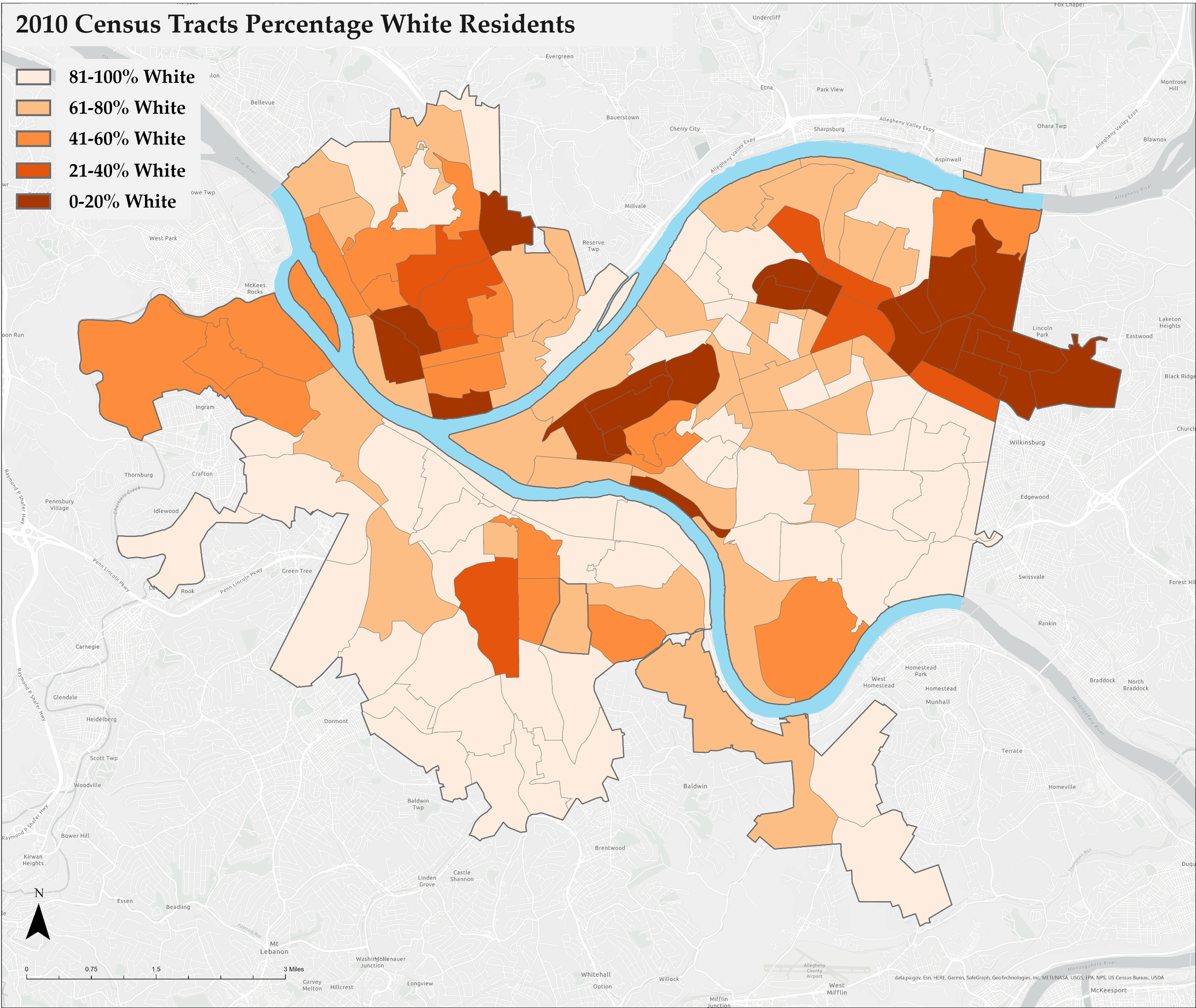
2010 Census Tracts
In 2010, census tracts where residents were over 60% White made up 69% of the city.
Race and Single-Family Zoning Districts 1927-2021
-

1927 Single-Family Districts Percentage White Residents
100% of the single-family zoning districts that were established in 1927 cover 1930 census tracts with a supermajority of White residents. -

1967 Single-Family Districts Percentage White Residents
98% of the 1967 single-family zoning districts cover 1960 census tracts with a supermajority of White residents. -

2021 Single-Family Districts Percentage White Residents
77% of the 2021 single-family zoning districts cover 2010 census tracts with a supermajority of White residents.
Race and Multi-Family Zoning Districts 1927-2021
-

1927 Multi-Family Zoning Districts Percent White Residents
3% of the 1927 multi-family zoning districts cover 1930 census tracts where at least 40% of the residents were not White. -

1967 Multi-Family Zoning Districts Percent White Residents
18% of the 1967 multi-family zoning districts cover 1960 census tracts where at least 40% of the residents were not White. -

2021 Multi-Family Zoning Districts Percent White Residents
56% of the 2021 multi-family zoning districts cover 2010 census tracts where at least 40% of the residents were not White.53% of these districts cover 2010 census tracts where at least 40% of the residents were Black.
Zoning and Race Summary
Between 1927 and 2010, the percent of the city with a supermajority of White residents diminished. There is a corresponding reduction in the link between supermajority White areas and the location of single-family zoning districts. However, over three-quarters of the 2021 single-family districts are still in areas with a supermajority of White residents in 2010.
Over the same 1927-to-2010 timespan, the multi-family zoning districts have seen an increasing concentration in areas of the city without a supermajority of White residents.
